Saturday, August 28, 2010

Flaming Gorge & Green River

Day 10 - I woke up at 6 AM to drive to the bottom of the Flaming Gorge Dam, but again, the fishing did not pick up until about 9AM since the water temperature was too cold.  The scenery was beautiful, the Flaming Gorge Dam was built in the 60's and is at an altitude of 6000ft, which means that the water is normally cooler.  


The Green River that flows from the dam was truly pristine (sometimes it takes an experience to realize what words were intended to mean) and teeming with fish.  Weirdly enough, I could see hundreds of fish 16"+ some 22"+, but up near the dam in slow moving water, these fish seemed to be spawning.  I concluded this in three ways:
1) There were pods of fish all around me, unafraid of my movements--I netted one that was too close just for fun. 
2) The couple that I caught were extremely lethargic.
3) I called the fly shop asking what the trouble was and he said, its an anomaly, but since the water is so cold and in really slow moving water, some trout spawn all year.  


Sure enough the fish were preoccupied and the fishing was not incredible.  A few times, a had a brown trout from a deep pool come up and stare at my fly three times in less than a minute, but never taking it.  I tied on 7x tippet (the thinest possible so it would be tough to see) and tried nearly a dozen variations and different flies.  I guess the Green River there is heavily pressured. I did have some luck, but given the number of fish that I saw, I shall return during another time of year.  But I wish not to detract from the beauty, the water is gin colored, the canyon is high, and there are many LARGE trout in the river. 


I set out to Jackson, WY from there, experienced an intense rain storm while driving on another mountain pass and strolled into Jackson Hole for a delicious and spicy Pad Thai dinner.  For now, I am going to crash at a hostel that has horrendously slow Wi-Fi after having a couple beers.  

Arches Natl. Park

Days 8-9 
I had an Einstein Bagel breakfast and then had the random luck that a Cabela's (an outdoor store) had the boots I needed to exchange. The welcoming signs as I left "Colorful Colorado" and entered Utah's "Life Elevated," were rather accurate.  Life at Arches was incredible, but also hot, arid, and sandy.

Balanced Rock

The Delicate Arch was extraordinary at sunset; the setting sun seemed to make its natural red tint furious.  The hike back was thankfully cooler since it was probably 100 degrees during the ascent.  That night, I drove to a suggested "night time photo shoot" spot and waited until the moon was high enough to lighten the night sky.  Later on I tried to sleep in my car, but could not get comfortable because with the cracked windows came in the bugs.
Delicate Arch
The highway that leads you into the park is the perfect precursor for an experience that just keeps getting better.  The red rocks got larger, the formations look like God sprinkled red dirt (as if it were salt) onto other larger rocks.  The heat was desert like and the park only had two watering stations... so it was pretty intense.  But I got acquainted with the sunset/sunrise times and planned on taking eight GBs of shots and videos.  I hiked 3-4 miles to Delicate Arch (the one on the Utah license plate) and met people from Spain, the UK, Germany, Switzerland, and all over the US including two ex-Gramercy residents. 

At Sunset
Sunset
Some arches lit up by the moon.  
Its wild to think that at one point everything in the park was the rocky bottom of a salty ocean.  Ravens flew everywhere and I wondered if they were waiting for us to die.  In some places you could see where the currents/rivers eroded the land as it swirled along a bend.  

I gave up trying to sleep at 6:15 AM, which was 5 minutes before my alarm was to go off.  I captured the Landscape Arch, which is barely (but incredibly) longer than a football field in nice sunrise light.  Then, I made my way to the most isolated and least visited arch in the park... Tower Arch.  To get there I needed to drive on an intense 4x4 road and then hike 3.6 miles.  The road, by the way, should have had a yellow triangle and exclamation point on the map, like on ski runs because theres a difference between an expert run and an EPIRB run! Anyway, I made it and the arch was worth it.  Although difficult to photograph since there was little room on either side to capture it (its in a canyon), it proved to be my favorite.
Sunrise
Sunrise at Landscape Arch
The 4x4 road!
Tower Arch
  

Two quick conclusions; the auxiliary driving lights that I installed ARE especially helpful at night.  Also, desert-life is undeniably a tough habitat to endure.  At all times, there was sand somewhere, in your ear, beard, food, eyes, etc.  After I had overdosed on the arches I set out to the Flaming Gorge in Northeastern Utah, where the fishing is supposedly special.  I snuck into a campsite that had hot showers, and then peeled out to a marina on the Flaming Gorge Reservoir.  Finally feeling clean, I made myself a nice dinner and crashed early night for a day full of fishing tomorrow. 

Thursday, August 26, 2010

Grand Junction, CO

Day 7 - I woke up and had a quick breakfast and then descended into Lake City, CO.  I drove past a few stocked lakes and asked a ranch hand, who seemed to own them, where to fish since everything seemed to be private.  He sent me to this nice stream, which I later learned didn't fish well since the water temperature was actually too low that early in the morning. 


Afterwards, I stopped at Dan's Fly shop near 9 AM and he, Dan himself, was an excellent source of info.  He told me that the famous Lake Fork of the Gunnison River (which I had researched) was accessible not too far from town.  Apparently, there are small private and public land indicators that take you into some nice water, but they are difficult to spot while driving.  He was more than right.  The Gunnison proved to be teeming with fish and was the juiciest of waters I have fished since Chile.  My pictures don't quite tell the story too well, and I caught a number of decent rainbows and brightly colored browns, but I am going to keep this spot to myself HAHA, since I snuck around some fences for the good stuff.  I took some back roads to avoid driving through Gunnison town to get to Grand Junction and this is what some of the driving was like. 


It did not compare to the last two passes so I was a bit bored, but I came to Grand Junction and found the cheapest motel in town after needing a long awaited shower.  To give you an idea of the culture of the town (in two small instances) I looked up the motels at some recreation playing field where I had phone service.  As I was parked, a beat up Oldsmobile pulled up with three angry and drunken hippies who were arguing about cigarettes.  The man in the passenger seat took off his glasses and asked me how I was doing.  I responded and returned the question to not be rude.  He said, "Im f***ing up, can't you tell?" Ummmm, yea.  His possey pulled out a blanket for the grass and chilled while I drove off.  


At Timbers Motel (a blue collar, working man's, weekly priced, type place), which was $40 + Wifi, the office man told me that they only had one non-smoking room available.  He tried to drill me to make sure I was not a smoker-I think he even got close enough to smell me.  Anyway, I cleaned up and had dinner and a beer at a sports pub across the street.  Grand Junction was nothing special, but was the refresher I needed.  

Wolf Creek Pass to Slumgullion Pass

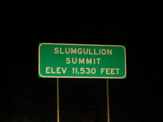
Day 6 - I left Pagosa Springs, CO and continued (NW) on a memorable drive over two mountain passes beyond Wolf Creek and Creede, CO.  I drove by a few lakes and streams that I had to try and fish.  The most productive spot was beyond a tunnel and down in a canyon about 200 ft.  This nice water produced some Brook trout that were not large, but were elegant in color.  


Brook Trout seem to be spatially aggressive, atypical of normally spooky trout.  

I finally had some phone service and caught up with the family and Claire.  I stopped at a small info sign and read that my route, almost in its entirety, up through Glacier National Park and through the rockies, paralleled the Continental Divide.  Obviously, I knew this, but it clicked why I was hugging high altitude mountain passes and finding fishy, cold water.  I kept on Highway 149 through Creede and up to Slumgullion Peak.  The drive through the Rio Grande National Forest was incredible. 
A rainbow after a shower and a Montana type, big sky, sunset colored the sky.

Rio Grande at sunset. 
Since most of the river is privately owned (which seems ridiculous), I will make it a plan to return.  The rest of the evening took me over another mountain pass that was higher, surrounded by pines, and reminded me of Dun Raven Pass in West Yellowstone.  When I thought that I would begin to descend I just kept climbing; oncoming cars would drive past me every twenty minutes, which made me think that it was probably less safe to drive through the pass at night.  The road took me to the mountain's peak and then about 1/4 mile later I saw a campground.


I must have slept at about 11,000 ft and it certainly felt that high. I ate some leftovers for dinner in my car since there had to be plenty of game up there.  Life of Pi ended up being the perfect book to listen to while driving (given the nature of my trip) except that my fear for big cats and/or brown bears grew tremendously.  So I loaded the shotgun just in case (JIC) and wrapped up in my down blanket since it was freezing.  The brightness of the moon was actually hurtful to stare at and it woke me up a few times as the light poked threw the trees late night (I thought that trees didn't grow above 10,000 feet, but they were everywhere).  If I was more brave I would have gotten out of my car and photographed the amazing shadows that the moon and the trees formed.  

Tuesday, August 24, 2010

San Juan Wilderness Area

Day 5 - Ben's uncle Kirk suggested that I spend some time in the San Juan Wilderness Area and get into accessible exclusive fishing and hiking.  I promised to keep the location a secret so the vagueness is intentional.  I drove thirteen miles into the wild in 4-wheel drive, averaging 10 mph, up and down steep hills with cliff edges that were casually too close.  Where the road ended the 3 mile trail began.  I knew it was wild because within 15 minutes of hiking I spotted numerous black bear tracks, some that were cub others that were adult, a small snake, an elk leg that was some beast's dinner, and a brewing thunderstorm that was terrifying.  


This furry creature has the most interesting call. 


Due to the relative nearness to the clouds (because of the altitude) and the echoing effect of the canyon; the thunder literally shook the mountain, even pine cones fell.  The rain poured on me for two hours, which made me feel small.  Since it had rained almost every day last week, the river was blown out (too muddy and too high), but I could tell it was fishy.  


Where I parked and slept helps put the area in perspective.  Since no one was around, I peed from a bridge forty feet off the ground, form where I took the picture of the 4Runner.  I ended up cooking rice and beans (you need so much more water and cooking time in higher altitude) and watched Saving Private Ryan in my car.  I was contemplating sleeping with my windows cracked for circulation, but also to be able to hear if a bear would come.  I got lucky not to hear anything.  


Hatcher Lake, CO

Day 4 - Ben's grandpa, Frank was nice enough to take me on one of the Pagosa Lakes near his home.  He taught me new and effective trout fishing techniques in deep water (like 28 ft).  I took a nice 20" bow and had two hogs that broke off.  

But Frank was masterful fishing this lake and took maybe 15 fish.  The big one that got away had ripped out some of his backing within 4 seconds and then broke off.  He did land a nice 21+ rainbow as well as some hefty perch.

Then Ben's aunt and uncle and family arrived from Hawaii, and we had dinner and mapped out pristine and secret places in the San Juan and Wimenuche Wilderness areas to explore.  

Saturday, August 21, 2010

Santa Fe - Pagosa Springs

En route from 64 (W) to 84 (N)
Day 3 -  I woke up, worked out, had some breakfast and headed out to the Reel Life Fly shop in downtown Santa Fe.  I got some pretty good advice on fishing the Rio Grande north of Embudo on highway 40.  The water was fishy, but since it was a Saturday there were about 30 white water boats, which were extremely frustrating, so I only took a few small bass.  The more exciting part of today was driving on Taos Wilderness back country roads that required 4-wheel drive.  Through Chama, NM and into Pagosa Springs, CO was an exciting drive because the terrain went from desert-like, dry, and hot, to high altitude, cool, and with a fresh pine aroma.  I got to see a red fox, a dike biker couple, and a table-top view of Pagosa Springs from the Chama mountain pass.  
I met up with Ben's grandparents who were very kind to take me in, take me out to dinner, and let me stay at their son's vacant apartment, where this erie turkey resides.   

Houston - Waco/Ft. Worth

Chinita's interpretation of my trip.
Day 1 - I just helped Mia move in at Baylor for her first year at college and said goodbye to my parents, who are now empty nesters.  After much anticipation, I have officially set off on my long awaited journey to Alaska.  Originally, I was offered an education position in Malaga, Spain teaching English on the beautiful Medeterrainian coast, but due to a finicky program and a lagging European economy, Spain could not afford my lousy wage.  Instead, I have chosen to take this time in my life to seek adventure.  


I plan on driving my 1997 Toyota 4x4 4Runner, which has 240K miles on it (because its a beast) all the way to Mt. McKinley in Denali National Park.  The route to Palin's land will connect the dots of the most scenic and best fishing spots throughout the Rockies, Alberta, British Columbia, the Yukon, and everywhere that the Alaskan Highway (and some ferries) can take me.  If you have seen any of the Trout Bum Diaries or love Ansel Adam's photography, you'll understand why I am doing this.  Although much of my route is technically planned, I have left some room for utter spontaneity.  There are friends and family to visit both on the way up and back, but for the first leg of the trip (nearly 4500 miles) I will be exploring solo. 
Cool physical plant near Ft. Worth, TX
But back to the trip, I left Waco to stay the night with Ben Swinney at his apartment near Ft. Worth.  He hooked me up with some cooking related "must haves" that I forgot like salt, a can opener, a Walmart gift card and the sorts, thanks. 

Day 2 - I departed near 10AM and drove on 287 (N) until I got to a random rest area near Santa Fe, NM.  On the drive I listened to Life of Pi on audiobook, stocked up on groceries at Walmart, and I tested the capacity of my fuel tank with the weight of my car.  I ran it dry which maxed out at 350 miles, so that I would know my approximate limit.  By the way, North Texas reminded me of the Big Lebowski because there were true rolling tumbleweeds and eight foot sunflowers.  
I arrived at my rest area about 9PM and there were New Mexican style stucco huts with picnic tables under them.  I filled up on water and broke in my cooking stove and lantern.  Even though there were trucks pulling in all night, I was relatively comfortable in my car and the temperature was nice and cool.  
Rest Area #1
**No part of this blog, whether the stories or photos, can be used without the written consent or permission of Ansel Orr.